Nevada
Nevada
From Wikipedia, the free encyclopedia
Nevada ( i/nəˈvædə/ or /nəˈvɒdə/) is a state in the western, mountain west, and southwestern regions of the United States. Nevada is the 7th most extensive, the 35th most populous, and the 9th least densely populated of the 50 United States. Over two-thirds of Nevada's people live in one single county, Clark County, which contains the Las Vegas–Paradise metropolitan area,[6] where the state's three largest incorporated cities are located.[7] Nevada's capital is Carson City.
Nevada is largely desert and semiarid, with much of it located within the Great Basin. Areas south of the Great Basin are located within the Mojave Desert, while Lake Tahoe and the Sierra Nevada mountains lie on the western edge. Approximately 86% of the state's land is owned by the US government under various jurisdictions, both civilian and military.[8]
The name Nevada is derived from the nearby Sierra Nevada mountains, which means "snow-capped mountain range" in Spanish. The land comprising the modern state was inhabited by Native Americans of the Paiute, Shoshone, and Washoe tribes prior to European contact.[9] It was subsequently claimed by Spain as a part of Alta California until the Mexican War of Independence brought it under Mexican control. The United States gained the territory in 1848 following its victory in the Mexican-American War and the area was eventually incorporated as part of Utah Territory in 1850. The discovery of silver at the Comstock Lode in 1859 led to a population boom that was an impetus to the creation of Nevada Territory out of western Utah Territory in 1861. Nevada became the 36th state on October 31, 1864.[10]
The establishment of legalized gambling and lenient marriage and divorce proceedings in the 20th century transformed Nevada into a major tourist destination.[11][12] The tourism industry remains Nevada's largest employer,[13] with mining continuing to be a substantial sector of the economy as Nevada is the fourth largest producer of gold in the world.[14]
Nevada is officially known as the "Silver State" due to the importance of silver to its history and economy. It is also known as the "Battle Born State" because it achieved statehood during the Civil War and the "Sagebrush State" for the native eponymous plant.
Etymology and pronunciation

The quartzite of the Prospect Mountain Formation on top of
Wheeler Peak, the highest peak entirely within Nevada
The name "Nevada" comes from the Spanish Nevada [neˈβaða], meaning "snow-covered",[15] after the Sierra Nevada ("snow-covered mountains") mountain range.
Nevadans normally pronounce the second syllable of their state name using the /æ/ vowel of "bad". Many from outside the Western United States pronounce it with the /ɑː/ vowel of "father" /nəˈvɑːdə/. Although the latter pronunciation is closer to the Spanish pronunciation, it is not the pronunciation preferred by locals. Notably, George W. Bush made this faux pas during his campaign for the 2004 US Presidential Election. Vindication later came when President Bush campaigned at the Reno-Sparks Convention Center on June 18, 2004. The president opened his talk by proclaiming that "It's great to be here in Nevada /nəˈˈvædə/," emphasizing the correct 'a' – the crowd roared its approval when he light-heartedly noted, "You didn't think I'd get it right, did ya?"[16] Bush subsequently carried the state in the election. Assemblyman Harry Mortenson has proposed a bill to recognize the alternate (quasi-Spanish) pronunciation of Nevada.[17]
Geography
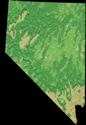
Digitally colored elevation map of Nevada
Nevada is almost entirely within the Basin and Range Province, and is broken up by many north-south mountain ranges. Most of these ranges have endorheic valleys between them, which belies the image portrayed by the term Great Basin.

Pinyon/
Juniper woodlands cover most of the mountain ranges in the northeastern and central portions of the state.

Basin and Range scenery near
Rachel
Much of the northern part of the state is within the Great Basin, a mild desert that experiences hot temperatures in the summer and cold temperatures in the winter. Occasionally, moisture from the Arizona Monsoon will cause summer thunderstorms; Pacific storms may blanket the area with snow. The state's highest recorded temperature was 125 °F (52 °C) in Laughlin (elevation of 605 feet / 184 metres) on June 29, 1994.[18] The coldest recorded temperature was −52 °F (−47 °C) set in San Jacinto in 1972, in the northeastern portion of the state.[18]
The Humboldt River crosses from east to west across the northern part of the state, draining into the Humboldt Sink near Lovelock. Several rivers drain from the Sierra Nevada eastward, including the Walker, Truckee and Carson rivers.
The mountain ranges, some of which have peaks above 13,000 feet (4,000 m), harbor lush forests high above desert plains, creating sky islands for endemic species. The valleys are often no lower in elevation than 3,000 feet (910 m).
The southern third of the state, where the Las Vegas area is situated, is within the Mojave Desert. The area receives less rain in the winter but is closer to the Arizona Monsoon in the summer. The terrain is also lower, mostly below 4,000 feet (1,200 m), creating conditions for hot summer days and cool to chilly winter nights (due to temperature inversion).
Nevada and California have by far the longest diagonal line (in respect to the cardinal directions) as a state boundary at just over 400 miles (640 km). This line begins in Lake Tahoe nearly 4 miles (6.4 km) offshore (in the direction of the boundary), and continues to the Colorado River where the Nevada, California, and Arizona boundaries merge 12 miles (19 km) southwest of the Laughlin Bridge.
The largest mountain range in the southern portion of the state is the Spring Mountain Range, just west of Las Vegas. The state's lowest point is along the Colorado River, south of Laughlin.
Nevada has 172 mountain summits with 2,000 feet (610 m) of prominence. Nevada ranks second in the US, behind Alaska, and ahead of California, Montana, and Washington. This makes Nevada the "Most Mountainous" state in the country, at least by this measure.
Climate
Nevada is the driest state in the US.[19] It is made up of mostly desert and semiarid climate regions, daytime summer temperatures sometimes may rise as high as 125 °F (52 °C) and nighttime winter temperatures may reach as low as −50 °F (−46 °C). While winters in northern Nevada are long and fairly cold, the winter season in the southern part of the state tends to be of short duration and mild. Most parts of Nevada receive scarce precipitation during the year. Most rain falls on the lee side (east and northeast slopes) of the Sierra Nevada. The average annual rainfall per year is about 7 inches (18 cm); the wettest parts get around 40 inches (100 cm). Nevada's highest recorded temperature is 125 °F (52 °C) at Laughlin on June 29, 1994 and the lowest recorded temperature is −50 °F (−46 °C) at San Jacinto on January 8, 1937. Nevada's 125 °F (52 °C) reading is the third highest temperature recorded in the U.S. just behind Arizona's 128 °F (53 °C) reading and California's 134 °F (57 °C) reading.
Vegetation
Nevada contains six biotic zones: alpine, sub-alpine, "Ponderosa Pine", "pinion-juniper", "sagebrush" and "creosotebush".[20]
Counties
Nevada is divided into political jurisdictions designated as counties. Carson City is officially a consolidated municipality; however, for many purposes under state law it is considered to be a county. As of 1919 there were 17 counties in the state, ranging from 146 to 18,159 square miles (380 to 47,030 km²). In 1969 Ormsby County was dissolved and the consolidated municipality of Carson City was created by the Legislature in its place co-terminous with the old boundaries of Ormsby County.
Nevada Counties
|
Carson City |
Carson City |
1861 |
55,274 |
2.63 % |
146 |
0.13 % |
359.29 |
|
Churchill |
Fallon |
1861 |
24,877 |
1.20 % |
5,023 |
4.54 % |
4.77 |
|
Clark |
Las Vegas |
1908 |
1,951,269 |
68.85 % |
8,091 |
7.32 % |
170.04 |
|
Douglas |
Minden |
1861 |
46,997 |
2.06 % |
738 |
0.67 % |
55.91 |
|
Elko |
Elko |
1869 |
48,818 |
2.27 % |
17,203 |
15.56 % |
2.63 |
|
Esmeralda |
Goldfield |
1861 |
783 |
0.05 % |
3,589 |
3.25 % |
0.27 |
|
Eureka |
Eureka |
1869 |
1,987 |
0.08 % |
4,180 |
3.78 % |
0.39 |
|
Humboldt |
Winnemucca |
1856/1861 |
16,528 |
0.81 % |
9,658 |
8.74 % |
1.67 |
|
Lander |
Battle Mountain |
1861 |
5,775 |
0.29 % |
5,519 |
4.99 % |
1.05 |
|
Lincoln |
Pioche |
1866 |
5,345 |
0.21 % |
10,637 |
9.62 % |
0.39 |
|
Lyon |
Yerington |
1861 |
51,980 |
1.73 % |
2,016 |
1.82 % |
17.11 |
|
Mineral |
Hawthorne |
1911 |
4,772 |
0.25 % |
3,813 |
3.45 % |
1.33 |
|
Nye |
Tonopah |
1864 |
43,946 |
1.63 % |
18,159 |
16.43 % |
1.79 |
|
Pershing |
Lovelock |
1919 |
6,753 |
0.33 % |
6,068 |
5.49 % |
1.10 |
|
Storey |
Virginia City |
1861 |
4,010 |
0.17 % |
264 |
0.24 % |
12.88 |
|
Washoe |
Reno |
1861 |
421,407 |
16.99 % |
6,551 |
5.93 % |
51.82 |
|
White Pine |
Ely |
1869 |
10,030 |
0.46 % |
8,897 |
8.05 % |
1.03 |
|
Totals |
Counties: 17 |
|
2,700,551 |
|
110,552 |
|
18.08 |
History
Before 1861

Sculpture representing a steam locomotive, in Ely, Nevada. Early locomotives played an important part in Nevada's mining industry
See History of Utah, History of Las Vegas, and the discovery of the first major U.S. deposit of silver ore in Comstock Lode under Virginia City, Nevada in 1859.
Separation from Utah Territory
On March 2, 1861, the Nevada Territory separated from the Utah Territory and adopted its current name, shortened from Sierra Nevada (Spanish for "snowy range").
The 1861 southern boundary is commemorated by Nevada Historical Markers 57 and 58 in Lincoln and Nye counties.
Statehood
Eight days prior to the presidential election of 1864, Nevada became the 36th state in the union. Statehood was rushed to the date of October 31 to help ensure Abraham Lincoln's reelection on November 8 and post-Civil War Republican dominance in Congress,[22] as Nevada's mining-based economy tied it to the more industrialized Union.
Nevada is notable for being one of only two states to significantly expand its borders after admission to the Union.[clarification needed] Nevada achieved its current southern boundaries on May 5, 1866, when it absorbed the portion of Pah-Ute County in the Arizona Territory west of the Colorado River, essentially all of present day Nevada south of the 37th parallel. The transfer was prompted by the discovery of gold in the area, and it was thought by officials that Nevada would be better able to oversee the expected population boom. This area includes most of what is now Clark County. In 1868 another part of the western Utah Territory, whose population was seeking to avoid Mormon dominance, was added to Nevada in the eastern part of the state, setting the current eastern boundary.
Mining shaped Nevada's economy for many years (see Silver mining in Nevada). When Mark Twain lived in Nevada during the period described in Roughing It, mining had led to an industry of speculation and immense wealth. However, both mining and population declined in the late 19th century. However, the rich silver strike at Tonopah in 1900, followed by strikes in Goldfield and Rhyolite, again put Nevada's population on an upward trend.
Gambling and labor

Gambling erupted once more following a recession in the early 20th century, helping to build the city of Las Vegas
Unregulated gambling was commonplace in the early Nevada mining towns but was outlawed in 1909 as part of a nation-wide anti-gambling crusade. Because of subsequent declines in mining output and the decline of the agricultural sector during the Great Depression, Nevada again legalized gambling on March 19, 1931, with approval from the legislature. Governor Fred B.Balzar's signature enacted the most liberal divorce laws in the country and open gambling. The reforms came just eight days after the federal government presented the $49 million construction contract for Boulder Dam (now Hoover Dam).[23]
Nuclear testing
The Nevada Test Site, 65 miles (105 km) northwest of the city of Las Vegas, was founded on January 11, 1951, for the testing of nuclear weapons. The site is composed of approximately 1,350 square miles (3,500 km²) of desert and mountainous terrain. Nuclear testing at the Nevada Test Site began with a 1 kilotonne of TNT (4.2 TJ) bomb dropped on Frenchman Flat on January 27, 1951. The last atmospheric test was conducted on July 17, 1962, and the underground testing of weapons continued until September 23, 1992. The location is known for having the highest concentration of nuclear-detonated weapons in the U.S.
Over 80% of the state's area is owned by the federal government. The primary reason for this is that homesteads were not permitted in large enough sizes to be viable in the arid conditions that prevail throughout desert Nevada. Instead, early settlers would homestead land surrounding a water source, and then graze livestock on the adjacent public land, which is useless for agriculture without access to water (this pattern of ranching still prevails).
Demographics
Growth
The United States Census Bureau estimates that the population of Nevada was 2,723,322 on July 1, 2011, a 0.84% increase since the 2010 United States Census.[1]
According to the Census Bureau's 2007 estimate, Nevada has an estimated population of 2,565,382 which is an increase of 92,909, or 3.5%, from the prior year and an increase of 516,550, or 20.8%, since the year 2000. This includes a natural increase since the last census of 81,661 people (that is 170,451 births minus 88,790 deaths) and an increase due to net migration of 337,043 people into the state. Immigration from outside the United States resulted in a net increase of 66,098 people, and migration within the country produced a net increase of 270,945 people. According to the 2006 census estimate, Nevada is the eighth fastest growing state in the nation.[24]
The center of population of Nevada is located in southern Nye County.[25] In this county, the unincorporated town of Pahrump, located 60 miles (97 km) west of Las Vegas on the California state line, has grown very rapidly from 1980 to 2010. At the 2010 census, the town had 36,441 residents.[26] Las Vegas was America's fastest-growing city and metropolitan area from 1960 to 2000, but has grown from a gulch of 100 people in 1900 to 10,000 by 1950 to 100,000 by 1970.[citation needed]

Nevada Population Density Map
From about the 1940s until 2003, Nevada was the fastest-growing state in the US percentage-wise. Between 1990 and 2000, Nevada's population increased 66.3%, while the USA's population increased 13.1%. Over two thirds of the population of the state live in the Clark County Las Vegas metropolitan area.
Henderson and North Las Vegas are among the USA's top 20 fastest-growing cities of over 100,000.
The rural community of Mesquite located 65 miles (105 km) northeast of Las Vegas was an example of micropolitan growth in the 1990s and 2000s. Other desert towns like Mercury and Searchlight on the outskirts of Las Vegas have seen some growth as well.
Large numbers of new residents in the state originate from California, which led some locals to feel that their state is being "Californicated".[27]
Largest Cities
Largest cities or towns of Nevada
http://nvdemography.org/data-and-publications/estimates/estimates-by-county-city-and-unincorporated-towns/ Offical 2011 State of Nevada estimates |
|
Rank |
City name |
County |
Pop.
|
|
1 |
Las Vegas |
Clark County |
588,274 |
|
2 |
Henderson |
Clark County |
264,839 |
|
3 |
North Las Vegas |
Clark County |
223,873 |
|
4 |
Reno |
Washoe County |
222,801 |
|
5 |
Sunrise Manor |
Clark County |
191,007 |
|
6 |
Paradise |
Clark County |
181,635 |
|
7 |
Spring Valley |
Clark County |
172,483 |
|
8 |
Enterprise |
Clark County |
160,632 |
|
9 |
Sparks |
Washoe County |
92,302 |
|
10 |
Carson City |
Carson City |
56,066 |
Top 10 locations by GDP in Nevada
Ranked by per capita income in 2000
|
Rank |
Place |
GDP |
County |
|
1 |
Incline Village-Crystal Bay |
$52,521 |
Washoe |
|
2 |
Kingsbury |
$41,421 |
Douglas |
|
3 |
Mount Charleston |
$38,821 |
Clark |
|
4 |
Verdi-Mogul |
$38,233 |
Washoe |
|
5 |
Zephyr Cove-Round Hill Village |
$37,218 |
Douglas |
|
6 |
Summerlin South |
$33,017 |
Clark |
|
7 |
Blue Diamond |
$30,479 |
Clark |
|
8 |
Minden |
$30,405 |
Douglas |
|
9 |
Boulder City |
$29,770 |
Clark |
|
10 |
Spanish Springs |
$26,908 |
Washoe |
|
|
continued on page 2
| Author: | Bling King |
| Published: | May 25th 2012 |
| Modified: | May 25th 2012 |


