Bering Strait
Bering Strait
From Wikipedia, the free encyclopedia
Coordinates:  66°0′N 169°0′W
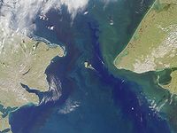
Satellite photo of the Bering Strait

Nautical chart of the Bering Strait

The
Peters map is parted in the Bering Strait.
* On other maps a part of Russia is shown left of Alaska.
The Bering Strait (Russian: Берингов пролив, Beringov proliv, Yupik: Imakpik[1][2]) is a 53 mile long sea strait between Cape Dezhnev, Chukotka Autonomous Okrug, Russia, the easternmost point (169°43'W) of the Asian continent and Cape Prince of Wales, Alaska, USA, the westernmost point (168°05'W) of the North American continent. It lies slightly south of the polar circle at approximately 65°40'N latitude, with the present US-Russia east-west boundary, agreed to only by the USA, at 168°58'37"W.
The Strait has been the subject of scientific speculation that humans migrated from Asia to North America across a land bridge known as Beringia when lower ocean levels–perhaps a result of glaciers locking up vast amounts of water–exposed a ridge beneath the ocean.[3]
The name of the sea containing the straight is sometimes spelled Behring in older books.
Geography and science
The Bering Strait is approximately 53 miles (85 km) wide, with depth varying between 98 feet (30 m) and 160 feet (49 m).[4] It connects the Chukchi Sea (part of the Arctic Ocean) to the north with the Bering Sea (part of the Pacific Ocean) to the south.
The International Date Line runs equidistant between the Strait's Diomede Islands at a distance of 1 mi (1.6 km), leaving the Russian and American sides usually on different calendar days, with Cape Dezhnev 21 hours ahead of the American side.
Population
The area is sparsely populated.
The area in the immediate neighborhood on the Alaskan side belongs to the Nome Census Area, home to a population of 9,000. No roads exist from the Strait to the main cities of Alaska, with only a few around Nome.
The Russian coast belongs to Chukotka Autonomous Okrug. Roadless Provideniya (4,500 people) and Chukotsky (5,200 people) lie along the Strait.
The Diomede Islands lie midway in the Strait. The village in Little Diomede has a school which belongs to Alaska's Bering Strait School District.
Expeditions
Semyon Dezhnyov (1648) was the first recorded European to pass through the Bering Strait. Dane Vitus Bering, serving on behalf of the Russian navy, entered it in 1728. In 1732 Mikhail Gvozdev crossed it for the first time, from Asia to America. Adolf Erik Nordenskiöld in 1878/79 sailed along the complete northern coast of Siberia, thereby proving that there was no northern land bridge from Asia to North America.
In March 1913 Captain Max Gottschalk (German) crossed from the east cape of Siberia to Shishmaref, Alaska on dogsled via Little and Big Diomede islands. He was the first documented modern voyager to cross from Russia to North America without the use of boat.[5]
In 1987 swimmer Lynne Cox swam the two miles (3 km) between the Diomede Islands from Alaska to the Soviet Union in 40 °F (4 °C) water during the last years of the Cold War.
In June and July of 1989 a British expedition, Kayaks Across The Bering Strait, completed the first sea kayak crossing of the Bering Strait from Wales (Kiŋigin), Alaska, to Cape Dezhnev, Siberia. The team brought a film crew with them and made the film Curtain of Ice.
In 1998, Russian adventurer Dmitry Shparo and his son Matvey made the modern crossing of the frozen Bering Strait on skis.
In March 2006 Briton Karl Bushby and French-American adventurer Dimitri Kieffer crossed the strait on foot, walking across a frozen 90 km (56 mi) section in 15 days.[6] They were soon arrested for not entering Russia through a border control.[7]
August 2008 marked the first crossing of the Bering Strait using an amphibious road-going vehicle. The specially modified Land Rover Defender 110 was driven by Steve Burgess and Dan Evans across the straits on its second attempt following the interruption of the first by bad weather.[8]
Proposed tunnel
Main article:
TKM-World Link
A physical link between Asia and North America via the Bering Straight nearly became a reality in 1864 when the Russian-American telegraph company began preparations for an overland telegraph line connecting Europe and America via the west. It was abandoned when the undersea Atlantic Cable proved successful.[citation needed]
Suggestions have been made to construct a Bering Strait bridge between Alaska and Siberia. However, despite the unprecedented engineering, political, and financial challenges, Russia green-lighted the US $65 billion TKM-World Link tunnel project in August 2011. If completed, the 103 km (64 mile) project would be the world's longest.[9]
The "Ice Curtain" border
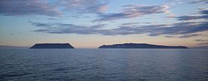
Little Diomede Island (USA, left) and Big Diomede Island (Russia, right).
During the Cold War, the Bering Strait marked the border between the Soviet Union and the United States. The island of Big Diomede in Russia is only 2.4 mi (3.9 km) from the island of Little Diomede in the USA. Traditionally, the indigenous peoples in the area had frequently crossed the border back and forth for "routine visits, seasonal festivals and subsistence trade", but were prevented from doing so during the Cold War.[10] The border became known as the "Ice Curtain".[11] It was completely closed, and there was no regular passenger air or boat traffic. In 1987, American swimmer Lynne Cox symbolically helped ease tensions between the two countries by swimming across the border[12] and was congratulated jointly by Ronald Reagan and Mikhail Gorbachev. Since 1990 tourist air and boat traffic exists, but is hampered by the need for visas and special military visit permits in this part of Russia.[citation needed]
| Author: | Bling King |
| Published: | May 26th 2012 |
| Modified: | May 26th 2012 |


